

UN approves new world map to show true size of Africa
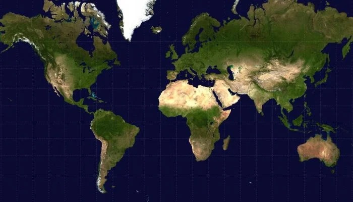
The UN new world map plan has gained major support after 164 countries backed a resolution promoting a more accurate view of Africa.
The United Nations General Assembly has backed a resolution encouraging the use of a map projection that better represents the actual size of continents.
The move focuses heavily on Africa, which appears much smaller on the commonly used Mercator map than it really is.
The resolution was supported by 164 countries, while six abstained and the United States voted against it.
Why Africa looks smaller
The issue comes from the way flat maps represent the round Earth.
The Mercator map was created for navigation and stretches areas farther from the equator. This makes regions such as Greenland and parts of North America and Europe appear much larger than their actual land area.
One striking example is Greenland and Africa.
On the traditional map, they can appear similar in size. In reality, Africa is about 14 times larger than Greenland.
This difference has led to long-running criticism about how world maps shape people’s understanding of different regions.
A new map could change the picture
The resolution promotes the Equal Earth projection, which keeps the relative area of continents much more accurate.
Unlike the Mercator projection, the Equal Earth design allows viewers to better compare the actual size of land masses.
The UN decision does not legally ban the older projection. Instead, it encourages governments, schools, publishers and other institutions to consider more accurate alternatives.
Togo sponsored the resolution as part of efforts to challenge the way Africa has traditionally been represented.
Read Also: New York schools impose one-year AI ban for young students
Why the decision matters
Supporters say maps are not simply pictures used to locate countries.
They can influence how people understand geography, importance and global relationships.
A map that makes some regions look much larger can affect how students and the public picture the world.
The Africa true size campaign therefore argues that a more balanced map could help correct a long-standing visual misunderstanding.
The UN new world map decision could encourage more institutions to rethink the maps they use in classrooms and digital platforms.
US opposes the move
The United States was the only country to vote against the resolution.
US officials argued that the UN should focus on more urgent international problems instead of debating map projections.
However, supporters say the issue is about more than cartography.
The Equal Earth projection is intended to provide a clearer comparison of land areas and challenge the distortions created by the traditional Mercator map.
What happens now?
The resolution is not legally binding, so the old map will not disappear overnight.
However, countries and organisations may gradually increase their use of the Equal Earth projection.
The Africa true size debate could therefore influence education, media and digital mapping in the years ahead.


